io.github.OpenCageData/opencage-geocoding-mcp MCP Server
io.github.OpenCageData/opencage-geocoding-mcp
Convert addresses to coordinates and vice versa using OpenCage's geocoding API.
What is the io.github.OpenCageData/opencage-geocoding-mcp MCP server?
The OpenCage Geocoding MCP Server is an MCP server that provides forward and reverse geocoding capabilities via the OpenCage geocoding API. It allows you to convert between addresses and geographic coordinates, and check your API usage and rate limits.
This server integrates OpenCage's geocoding API into Claude and other MCP-compatible clients, enabling you to look up coordinates for addresses and place names, reverse-lookup addresses from coordinates, and monitor your API usage. It's designed for small-scale geocoding tasks within LLM conversations rather than bulk data processing.
How to install io.github.OpenCageData/opencage-geocoding-mcp
Copy-paste configuration for popular MCP clients.
YOUR_API_KEYrequiredsecretYour API key for the service
Tools & capabilities
Tools this server exposes to the agent.
geocode-forward— Convert an address or place name to coordinates and location information. Supports optional country code, bounding box, language, result limits, and annotation filtering.geocode-reverse— Convert latitude and longitude coordinates to an address and location information. Supports optional language and annotation filtering.get-opencage-info— Check your current API usage, rate limits, and reset times for your OpenCage account.
Use cases
- Find coordinates for a specific address or landmark to use in mapping or location-based applications
- Identify what address or location corresponds to a given latitude/longitude pair
- Determine administrative divisions (country, state, province, department) for a location
- Check your OpenCage API quota and usage before making geocoding requests
- Look up location details like timezone and local currency for a place
io.github.OpenCageData/opencage-geocoding-mcp MCP server FAQ
It's an MCP server that connects Claude and other MCP clients to the OpenCage geocoding API, allowing you to convert between addresses and coordinates, and check your API usage.
OpenCage offers a free trial API key. Paid subscription plans are available for higher usage volumes. See opencagedata.com for pricing details.
Clone the repository, run `npm install`, then add the server configuration to your Claude Desktop config file (`~/Library/Application Support/Claude/claude_desktop_config.json` on Mac) with your OpenCage API key.
Yes, you must sign up at opencagedata.com to get a free-trial geocoding API key and set it as the `OPENCAGE_API_KEY` environment variable.
No. This MCP is designed for small amounts of geocoding in interactive LLM conversations. For bulk processing of CSV files or databases, OpenCage recommends using their command-line tools or writing a script to call the API directly.
The geocoding results can be returned in multiple languages (e.g., 'en', 'de', 'fr') via the optional `language` parameter.
README (reference)
Source of truth, from the repository.
OpenCage Geocoding MCP Server
An MCP (Model Context Protocol) server that provides geocoding capabilities using the OpenCage geocoding API. This server allows you to convert between addresses and geographic coordinates.
PLEASE NOTE: the examples shown here are based on an integration with claude.ai's desktop client. MCP as a concept is supported by other services, but may require a slightly different configuration.
Features
- Forward Geocoding: Convert addresses or place names to coordinates (latitude/longitude)
- Reverse Geocoding: Convert coordinates to addresses
- API Status Monitoring: Check your API usage and rate limits (assuming your penCage account has hard limits).
Prerequisites
- Node.js (version 20 or higher)
- OpenCage geocoding API Key: Sign up on the OpenCage website to get a free-trial geocoding API key
Installation
-
Is MCP the right tool?
This MCP is the right tool for small amounts of geocoding, for example while manually prompting an LLM.
If however, you want to process larger volumes of data, for example CSV files full of address or coordinates, or connecting to database full of data, it is almost certainly both faster and more affordable to use our command line tools, or have the LLM write a script to call our API directly.
We offer a markdown-formatted opencage-geocoding-api SKILL file to train your AI on best practices for working with our geocoding API.
-
Clone the repository. Change into the repository directory
git clone git@github.com:OpenCageData/opencage-geocoding-mcp.git
# or
git clone https://github.com/OpenCageData/opencage-geocoding-mcp.git

cd opencage-geocoding-mcp
- Install dependencies:
npm install
This is enough to get the MCP working with Claude Desktop (see below)
If you want to develop the MCP and plan to query the MCP from the command line you will also need to:
- Set your OpenCage geocoding API key as an environment variable:
export OPENCAGE_API_KEY="your_opencage_geocoding_api_key_here"
- Build the project:
npm run build
Usage
Using within Claude Desktop
Add this configuration to your Claude Desktop config file
On a Mac the config file should be (~/Library/Application Support/Claude/claude_desktop_config.json), but you can also navigate to the file via the menu: Settings > Developer > Edit Config
{
  "mcpServers": {
    "opencage-geocoding": {
      "command": "node",
      "args": ["/ABSOLUTE/PATH/TO/opencage-geocoding-mcp/build/index.js"],
      "env": {
        "OPENCAGE_API_KEY": "your_opencage_geocoding_api_key_here"
      }
    }
  }
}
Available Tools
Note: the first time you run a command you will need to give Claude permission
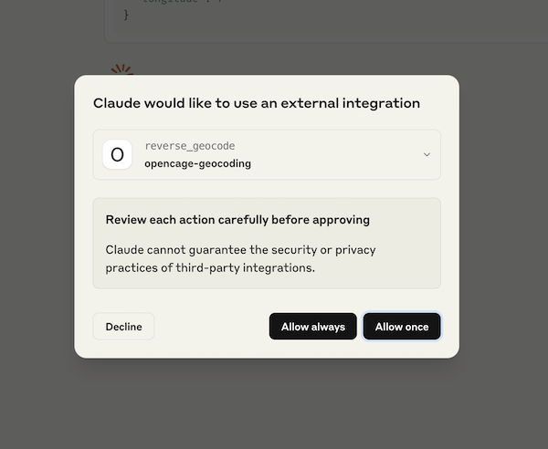
1. geocode-forward
Convert an address or place name to coordinates and information about that location.
Parameters:
query(required): The address or place name to geocodecountrycode(optional): Restrict to country (ISO 3166-1 alpha-2 code)bounds(optional): Bounding box (min_lon,min_lat,max_lon,max_lat)language(optional): Language for results (e.g., 'en', 'de', 'fr')limit(optional): Max results (1-100, default 10)no_annotations(optional): Exclude location annotations
Example prompts
Prompt: "What are the coordinates of Trafalgar Square, London?"
Result: coordinates, timezone, local currency, etc

Prompt: "Where is Les Vans, France? Which Department is it in?"
Result: coordinates, and correct answer that Les Vans is in the Ardèche department

Prompt: "In welchem Bundesland liegt Weimar?"
Result: coordinates, and correct answer that Weimar is in Thüringen
2. geocode-reverse
Convert coordinates to an address and information about that location
Parameters:
latitude(required): Latitude coordinate (-90 to 90) in decimal formatlongitude(required): Longitude coordinate (-180 to 180) in decimal formatlanguage(optional): Language for resultsno_annotations(optional): Exclude location annotations
Example prompts
Prompt: "what is the address at 38.8976, -77.0365?"
Result: "1600 Pennsylvania Avenue NW, Washington, DC 20500, United States of America"

Prompt: "Which province are the coordinates 41.38700, 2.16995 in?"
Result: "Coordinates are in Barcelona in the province of Catalonia"
3. get-opencage-info
Check your current API usage and rate limits. NOTE: subscription customers do NOT have hard usage limits. See relevant documentation.
Parameters: None
Returns: Information about remaining requests, rate limits, and reset times.
Available Prompts
geocoding-assistant
A helpful assistant for geocoding tasks. Provides guidance on using the geocoding tools effectively.
Error Handling
The server includes comprehensive error handling:
- Invalid API keys
- Rate limit exceeded
- Network errors
- Invalid coordinates or addresses
- API service unavailable
Environment Variables
OPENCAGE_API_KEY: Your OpenCage geocoding API key (required)
Troubleshooting
- "API key required" error: Make sure the env var
OPENCAGE_API_KEYis set - "No results found": Try a more specific or different address format, see the OpenCage guide to query formatting
- Rate limit errors: Check your API usage with
get-api-statustool - Network errors: Verify internet connection or the public OpenCage status page
Relevant Links
-
OpenCage homepage - Get your geocoding API key
-
OpenCage API Documentation - Full OpenCage geocoding API reference
-
Model Context Protocol - Learn more about MCP
Who is OpenCage GmbH?
<a href="https://opencagedata.com"><img src="opencage_logo_300_150.png"></a>
We run a worldwide geocoding API and geosearch service based on open data. Learn more about us.
We also organize Geomob, a series of regular meetups for location based service creators, where we do our best to highlight geoinnovation. If you like geo stuff, you will probably enjoy the Geomob podcast.
Related MCP servers
Search PII-free opportunities, availability, and live events; prepare safe no-write form handoffs.

OpenHCS
Inspect, author, validate, and run high-content microscopy workflows.


OpenImageDebugger MCP
Visualize in-memory buffers during GDB/LLDB debugging sessions with an MCP server for AI agents.

Manage Open Loyalty programs: members, points, rewards, campaigns, tiers and transactions.
View repository →
OpenOSINT
AI-powered OSINT agent with 18 investigation tools: email, breach, IP, WHOIS, DNS, Shodan, GitHub, and more.